The term “Carte de l’Afrique,” which translates to “Map of Africa” in English, encompasses far more than mere geographical delineations. It serves as a gateway to exploring Africa’s rich and diverse landscapes, intricate cultural mosaics, and dynamic socio-political contexts. This article delves into the multifaceted aspects of Africa’s map, highlighting its geographical diversity, cultural significance, historical context, and the role modern cartography plays in shaping our understanding of this vast continent.
The Geographic Diversity of Africa
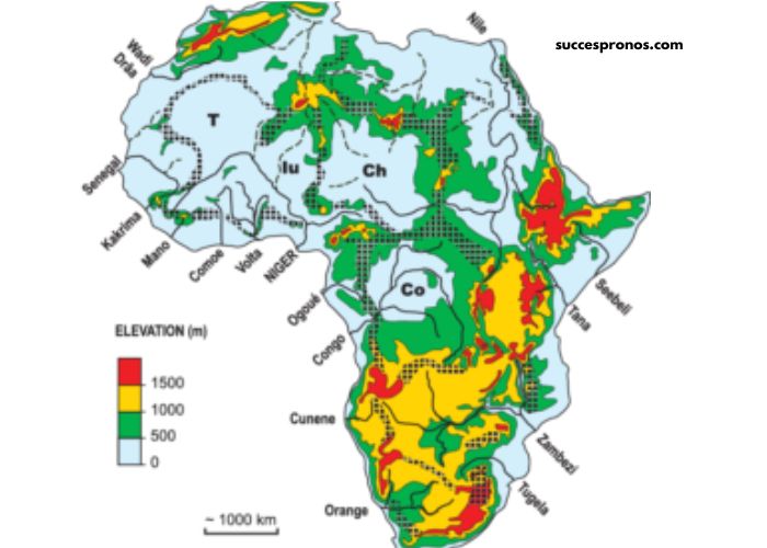
Africa is renowned for its remarkable geographic diversity. From the vast Sahara Desert in the north to the lush rainforests of Central Africa and the diverse savannas of the east, the continent’s landscape is varied and unique. The Carte de l’Afrique illustrates this diversity with detailed representations of mountains, rivers, lakes, and other natural features that define the continent’s physical geography.
Mountains and Highlands
The map of Africa prominently features several major mountain ranges, each with its own ecological and climatic impacts. The Atlas Mountains stretch across North Africa, creating a barrier between the Mediterranean coastline and the Sahara Desert. In the East, the Ethiopian Highlands, often referred to as the Roof of Africa, are home to some of the continent’s highest peaks, including Mount Ras Dashen. The Drakensberg Mountains in South Africa further illustrate the continent’s varied topography, influencing local climates and ecosystems.
Rivers and Lakes
Africa is home to some of the world’s most significant rivers and lakes, which are crucial to both its ecology and human settlements. The Nile River, flowing from the highlands of East Africa to the Mediterranean Sea, is often celebrated as the longest river in the world. The Congo River, with its vast basin, is a major source of biodiversity and plays a central role in the region’s ecological balance. Additionally, Africa’s lakes, such as Lake Victoria, Lake Tanganyika, and Lake Malawi, are among the largest in the world and are vital for the livelihoods of millions of people.
Deserts and Rainforests
The Carte de l’Afrique highlights Africa’s climatic extremes, including the Sahara Desert, which spans much of North Africa. This arid expanse influences the climate and weather patterns across the continent, affecting everything from agriculture to human habitation. In contrast, Central Africa’s rainforests, particularly the Congo Basin, represent one of the world’s largest and most diverse tropical forests, hosting an incredible array of flora and fauna.
Cultural and Ethnic Diversity
The map of Africa also serves as a backdrop for understanding the continent’s rich cultural and ethnic diversity. Africa is home to over 3,000 ethnic groups, each with its own distinct languages, traditions, and histories. The Carte de l’Afrique provides insight into the regional distribution of these groups and their cultural practices.
North Africa
In North Africa, the map reveals a predominantly Arab-Berber cultural landscape. Countries like Morocco, Algeria, Tunisia, and Egypt showcase a blend of Arab culture with indigenous Berber influences. The historical significance of North Africa is underscored by its role as a crossroads of ancient civilizations, including the Phoenicians, Egyptians, and Romans.
Sub-Saharan Africa
Sub-Saharan Africa is incredibly diverse, with significant cultural variations across regions. West Africa, for instance, is known for its vibrant traditions, including the rich musical heritage of the Yoruba and the intricate art and crafts of the Ashanti. East Africa’s cultural landscape is shaped by the Swahili culture along the coast, the Maasai tribes in Kenya and Tanzania, and the various ethnic groups of Ethiopia.
Southern Africa
Southern Africa, depicted on the Carte de l’Afrique, includes a range of cultures from the Zulu and Xhosa peoples of South Africa to the Shona and Ndebele in Zimbabwe. The region is also marked by the complex interplay of indigenous cultures and colonial influences, which have shaped its modern social and cultural dynamics.
Historical Context and Colonial Legacy
The Carte de l’Afrique is not only a geographical tool but also a historical document that reflects the colonial and post-colonial transformations of the continent. European colonization in the late 19th and early 20th centuries significantly altered Africa’s political and cultural landscape, with borders drawn often with little regard for existing ethnic and cultural divisions.
Colonial Boundaries
The Berlin Conference of 1884-1885, which formalized European claims to African territories, resulted in the creation of new borders that did not align with traditional ethnic or cultural boundaries. This legacy of artificial borders has had long-lasting effects on Africa’s political and social cohesion, leading to various challenges in nation-building and regional integration.
Post-Colonial Changes
Following the wave of independence movements in the mid-20th century, many African countries sought to redefine their identities and governance structures. The Carte de l’Afrique from this period reflects new national borders and the emergence of independent states. This post-colonial era has been characterized by efforts to address the legacies of colonialism and foster economic and political development.
Modern Cartography and Technology
In the contemporary era, advancements in technology have transformed how the Carte de l’Afrique is created and utilized. Modern cartography combines traditional methods with sophisticated technologies to provide detailed and accurate representations of Africa’s geography.
Geographic Information Systems (GIS)
Geographic Information Systems (GIS) have revolutionized the mapping process by allowing for the integration of various data layers, including topography, land use, and demographic information. GIS technology enables the creation of dynamic and interactive maps that can be used for a range of applications, from urban planning to environmental management.
Remote Sensing
Remote sensing technologies, such as satellite imagery, provide valuable data for updating and refining maps of Africa. Satellite images offer detailed views of landscapes, enabling the monitoring of changes in land cover, vegetation, and urban development. This technology supports a range of applications, from disaster response to natural resource management.
Digital Mapping Tools
Digital mapping tools and online platforms have made it easier for users to access and interact with maps of Africa. Platforms like Google Maps and OpenStreetMap offer real-time navigation, geographic information, and the ability to explore various aspects of the continent’s geography from a digital perspective. These tools enhance accessibility and provide up-to-date information for users worldwide.
The Role of the Carte de l’Afrique in Education and Research
The Carte de l’Afrique plays a crucial role in education and research by providing a foundation for understanding the continent’s geography, cultures, and historical contexts. It is used in various academic disciplines, including geography, history, anthropology, and political science.
Educational Resources
In educational settings, maps of Africa are essential tools for teaching students about the continent’s physical and cultural geography. They help students visualize geographical features, understand cultural diversity, and explore historical developments. Educational maps also support curriculum development and classroom instruction, making complex concepts more accessible.
Research and Policy Development
For researchers and policymakers, the Carte de l’Afrique provides critical data for analyzing regional and global issues. It supports research on topics such as climate change, resource management, and socio-economic development. By offering detailed geographic and cultural information, the map helps inform policy decisions and strategic planning.
Conclusion
The Carte de l’Afrique serves as a vital resource for understanding the continent’s geographic and cultural complexity. Beyond its role as a geographical tool, it offers insights into Africa’s diverse landscapes, rich cultural tapestry, and historical evolution. Modern advancements in cartography and technology continue to enhance our understanding of Africa, providing valuable data for education, research, and policy development. As we explore the map of Africa, we gain a deeper appreciation of the continent’s dynamic and multifaceted nature, reflecting its significance in the global context.